
Setting the Catchment Context
The AWS Standard framework encourages operational sites to view water stewardship activities more holistically and within a catchment context. The AWS Standard helps drive change and guides water stewards to identify opportunities ‘outside the fenceline’ by following a common-sense approach that begins with gathering information and understanding context, starting with the catchment.
By Penelope Moskus, Senior Environmental Scientist (Ann Arbor, MI) and Rodney Feddema, Environmental Scientist (Los Angeles, CA)
April 7, 2023
For most companies, local water stewardship action is centered around an operational site such as a manufacturing facility or office campus. The AWS International Water Stewardship Standard (AWS Standard) framework encourages these facilities to view water stewardship activities more holistically within a catchment context.
The AWS Standard helps drive change and guides water stewards to identify opportunities ‘outside the fenceline’ by following a common-sense approach that begins with gathering information and understanding context. The most important boundary for understanding context is the catchment, within which water quantity and quality may impact or be impacted by a site. The catchment also helps delineate the region or boundary to identify water-related risks shared by the site and stakeholders and opportunities to address shared water challenges.
Many of the Step 1 (Gather and Understand) criteria focus on characterizing the catchment by collecting and synthesizing information on the following:
- The site’s water sources, discharge locations, and the catchments that the site affect(s) and upon which it is reliant (Criteria 1.1)
- Relevant stakeholders and their water-related challenges (Criteria 1.2)
- Water-related data for the catchment, including Important Water-Related Areas, infrastructure, and WASH (Criteria 1.5)
- Current and future shared water challenges in the catchment (Criteria 1.6)
- Site water risks and opportunities (Criteria 1.7) Relevant catchment best practices toward achieving AWS outcomes (Criteria 1.8)
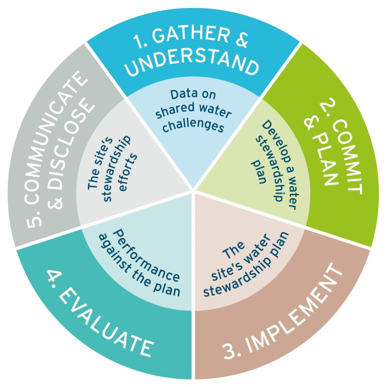
Subsequent steps involve committing and planning, implementing, and evaluating, which are also conducted within the catchment context.
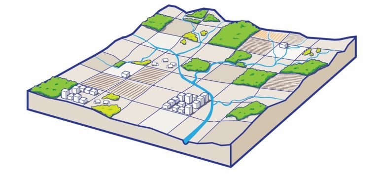
How is a catchment defined?
AWS guides sites in identifying their catchment boundary(ies) and context, including both the catchment where the site is physically located and the catchment(s) that supply water for the site and those that the site affects.
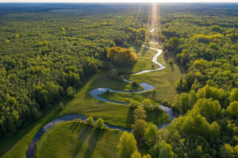
A catchment (also referred to as a watershed or basin) is defined as a land area that channels or moves rainfall and snowmelt that has fallen on the land surface to creeks, streams, and rivers, and eventually to outflow points such as lakes, reservoirs, bays, and the ocean.
Model My Watershed, a web tool that can be used to analyze mapped watershed data, is a useful resource for catchment delineation in the contiguous United States. Globally, the major and minor basin boundaries provided by The Food and Agriculture Organization (FAO) and HydroSHEDS include catchment boundaries, river networks, and lakes and can provide a starting point for determining a site’s catchment.
Why is the catchment an important scale?
With regard to water, the phrase “We all live downstream” refers to the fact that actions upstream in a catchment can affect downstream areas and inhabitants. These actions may impact water quantity, access, quality, and important water-related areas. For example, land cover change can increase stormwater runoff and increase downstream flooding. Increased water demand in a catchment or drought may limit water availability for others that rely on the same source, as experienced by communities in South Africa and the Colorado River basin in recent years. Even in the water-rich Great Lakes region, access to drinking water has been impacted by lead in water distribution pipes, PFAS in groundwater, and harmful algal blooms (HABs) in Lake Erie.
The concept of catchment management is not new.
In 1878, John Wesley Powell recognized the importance of the catchment context for arid regions of the US, proposing irrigation systems and state boundaries based on catchment areas to avoid disagreements between states. The Clean Water Act (1972) requires each state to develop Total Maximum Daily Loads (TMDLs) for all waters identified on their 303(d) list of impaired waters. TMDLs are scaled at the catchment (i.e., watershed) level to link causes of waterbody impairment to their impacts and determine the pollutant load reductions needed to meet applicable water quality standards. TMDL development involves public meetings and watershed implementation plan development, paralleling many of the AWS criteria.
A recent example from the Great Lakes region highlights the linkage between water risks at the site (water utility) and catchment level. In August 2014, toxins from a harmful algal bloom triggered warnings for Toledo, Ohio, residents not to drink or touch their water. Residents of Pelee Island, Ontario, received a similar message later that month. These harmful algae blooms were caused by high phosphorus concentrations in Lake Erie, which predominantly came from agricultural runoff from the Lake Erie watershed.
Ohio, Michigan, and Ontario have since adopted a goal to reduce phosphorus entering Lake Erie (i.e., from the Lake Erie watershed) by 40% by 2025. Since 2015, water utilities that source from Lake Erie have contracted with LimnoTech to deploy and maintain real-time water quality and harmful algal bloom monitoring sensors at 12 public water systems on Lake Erie. These data, available through the “HABS Data Portal,” provide an early warning system to water utilities. Utilities and other water users are also engaging with stakeholders and researchers to gather information and understand how to reduce the size and frequency of future blooms.
TMDLs are driven by regulation; the response to harmful algal blooms is driven by urgency. Within the corporate water stewardship space, our clients implement AWS or otherwise engage beyond their fenceline voluntarily, generally following similar steps that are focused at a catchment level. These leading organizations set operational targets that drive engagement, develop water stewardship plans that consider stakeholder input and site risk and implement and assess projects beyond their fenceline to address shared challenges in the catchments where they operate, source materials, and live.
Our AWS Professionally Credentialed staff are supported by engineers, scientists, hydrologists, geologists, and planners who are skilled at defining the physical scope of a site based on the catchment context and using that context to identify relevant water stewardship actions and engagement opportunities. Our team can ensure your AWS journey begins with a solid understanding of the physical scope and catchment context so that the subsequent steps are focused on making an impact.
If you want to discuss your water stewardship or AWS Standard implementation needs, please get in touch with Penelope Moskus at pmoskus@limno.com.
This article is the seventh in a series of articles authored by LimnoTech staff on water stewardship. Follow us on LinkedIn or Twitter (@LimnoTech), and check our website’s Insights & Perspectives page for more information and updates.
Links to the other water stewardship articles in this series are provided below:
The Alliance for Water Stewardship Standard – Framing a Decade of Water Stewardship
Understanding and Engaging Water-Related Stakeholders
Assessing Water-Related Risk As A Foundation For Stewardship
Success Strategies for Developing a Site Water Stewardship Plan within the AWS Standard Framework
Strong Site Teams Lead To Successful Water Stewardship
Penelope Moskus is a Senior Environmental Scientist and Project Manager with over two decades of experience. She supports LimnoTech’s water sustainability consulting services, helping clients develop strategies, guidance, and tools to reduce water-related risks. For over a decade, she has evaluated volumetric and complementary benefits of potential and funded projects and annually supports corporate reporting for numerous companies. She has supported the replenishment program of a major food and beverage company for over a decade, including programmatic support, volumetric benefit quantification, reporting, verification, and tool development. She provides similar services for a wide range of clients, including global and local NGOs, food and beverage companies, energy providers, high-tech companies, agricultural providers, and a national supermarket chain. Penelope is an accredited consultant for AWS International Water Stewardship Standard and contributed to a landmark paper on Volumetric Water Benefit Accounting.
Rodney Feddema joined LimnoTech in 2021 as an Environmental Scientist and has since worked on stormwater modeling, geochemistry, and corporate water stewardship. Rodney previously worked at Wood Environment & Infrastructure Solutions, where he studied the impacts of erosion and sedimentation on coastal lagoons, evaluated the feasibility of recycling stormwater runoff for municipal use, and implemented green infrastructure BMPs. In San Diego State University’s Watershed Science Master’s program, Rodney researched the impacts of groundwater quality on crop production in Mexicali, Mexico, while teaching lab courses in the geography department. At UC Santa Barbara, Rodney explored the connections between drought, wildfire, and streamflow in the Sierra Nevada mountains while completing his Bachelor of Science in Environmental Studies. Throughout his career, Rodney has combined his technical skills in hydrological modeling, ArcGIS, R, and Python with his experience in stakeholder engagement, project management, and technical writing to help solve complex and interdisciplinary water resources problems.
The content herein is the author’s opinion and not published on behalf of the Alliance for Water Stewardship (AWS). The author holds an AWS Professional Credential and this piece of publishing helps fulfill their Continuing Contribution Units requirements. For more information about AWS or the AWS Professional Credentialing Program please visit https://a4ws.org/.
